Monday, February 27, 2012

DEVONPORT

SUNDAY 26.2.2012: Had read about "Tasmania's Largest Undercover Market" held every Sunday at Penguin so we headed on out. As always we managed to purchase something and had a relaxed morning listening to live music and wandering round. Called in for a refreshment at Turner's Beach (Population: 1,477), overlooking the Don River (Carole's Fathers' Christian name) on our way back.
DON RIVER

Sunday, February 26, 2012

DEVONPORT

FRIDAY 24 - SATURDAY 25.2.2012: In preparation for our return trip to the "mainland", we had organised for a two night stay at the Abel Tasman Caravan Park. Arrived at the park and were advised that we should have been here yesterday - YES, we would have "missed the boat"! Fortunately we had already made the decision to extend our time in Tasmania and will now be returning on Friday 23 March. We have thoroughly enjoyed our time here and as yet have not even made it to the  north east coast.

PENGUIN - POPULATION: 2,943

THURSDAY 23.2.2012: Onward to Penguin which was first settled in 1861 as a timber town, and proclaimed on 25 October 1875. The area's dense bushland and easy access to the sea led to Penguin becoming a significant port town, with large quantities of timber shipped across Bass Strait to Victoria, where the 1850s gold rushes were taking place. The town was named by the botanist Ronald Campbell Gunn for the Fairy Penguin rookeries that are common along the less populated areas of the coast. We stayed at Penguin's Lion Park overlooking the water. 

Saturday, February 25, 2012

WYNYARD

TUESDAY 21 - WEDNESDAY 22.2.2012: Stayed two nights at Oldina Picnic Area, but alas it rained! Did enjoy a visit from a family of black parrots - little too high in the tree for our toy camera to take a clear shot. Returned to Wynyard and spent the day on domestics - pulled up for the evening at Wynyard Showground.

Thursday, February 23, 2012

STANLEY

- LES
- LES' BOAT
- LEGEND!
MONDAY 20.2.2012: Although a little windy, the weather was fine so Les decided we would set sail. Due to our previous charter experiences we had resigned ourselves to the fact that irrespective of outcome it would be nice on the water. We left the boat ramp and were immediately surrounded by a pod of dolphins - so many that you could not count them and so close you could have lent over and touched them - just magic. Les lost the dolphins and advised us to throw our lines in - from that point on we caught fish and missed bites that we should have landed! Had we been by ourselves "brag time, fish measurement and photographic opportunities" would have been incorporated! Instead, trying to present as "fishing professionals" we calmly muttered a "well done" whilst inwardly screaming like teenagers and desperately trying to keep tally of each other's haul (no competition), all to the dulcet tones of Les' "throw your line in". We caught Australian Salmon, Wrasse (Blue Throat and Brown), and Flathead - Les aims for four different species.
DID MANAGE SOME PHOTOS!


SEALS & CORMORANTS OF STANLEY
Les' knowledge is immeasurable and you knew if you spent years with him there would always be something to be learnt - his other passion is wooden boat restoration. En route we also had the opportunity to view Stanley's seal colonies at close quarters. Today was one of those experiences that you fully appreciate after the event. We were so focused on applying and remembering the fishing techniques, catching the fish and appreciating what nature had on offer that the time passed without realising what enormous pleasure had been gained.
We raced back to the motorhome and recorded all the fishing tips we could recall. Needless to say, if you ever visit Stanley a fishing charter with Les Sims is a "must do". We returned to our other favourite place - Oldina Picnic Area. By the campfire we smugly gloated that never had we learnt s-o much, caught s-o many fish that were 
s-o big, saw s-o many dolphins and seals s-o close and all in such a short time frame - perfect day! 
LESSON IN FILLETING -
LOOK AT THE SIZE OF THAT FISH!

Wednesday, February 22, 2012

STANLEY

FRIDAY 17 - SUNDAY 19.2.2012: On the way back to Stanley (one of our favourite haunts), we stopped at the Tarkine Forest Adventure at Dismal Swamp. This is a 600-hectare blackwood 'polje' (pol-ya), a special type of sinkhole and the only one of its kind in the world. A sinkhole is a sign on the earth's surface of an underground world of caves and streams. The swamp is at the bottom of the sinkhole, surrounded by steep walls formed over thousands of years by dissolving rocks known as dolomite. You have the option of taking a 15 second "slide" down to the bottom of the sinkhole - we did consider it, but decided that the old girl's (Sybil's that is), metal joints may not be up to the challenge! SO, we walked all the way down and back up again!
THE SLIDE INTO THE SINKHOLE

 
"LIVING ROOM" - SIMON ANCHER

"LOOKING" (AT A 500 YEAR OLD MYRTLE) - BOB JENYN

On our arrival at Stanley we organised for 3 hours on a fishing charter. Les Sims had been recommended so we made contact - then the rains came! The decision was made to wait till Monday and if the weather was still poor we would move on.

ARTHUR RIVER

THURSDAY 16.2.2012: "The Edge of the World" - Arthur River is the name of both a river and a small township on the northern part of the West Coast of Tasmania. It is south of the town of Marrawah. Named after Sir George Arthur, Lieutenant Governor of Van Diemens Land (1824-36), the river is fed by several tributaries including the Frankland River, which was named after its discoverer, then the colony's surveyor-general. The region has been exploited commercially for timber and fisheries, but today is mostly a centre for tourism. On the coast near the mouth of the Arthur River is a plaque titled The Edge of the World. North West Coast Tasmania, and a poem by tourism pioneer Brian Inder, who coined the term, referring to the coastline at Arthur River which is regularly lashed by the gales of the Roaring Forties.

"EDGE OF THE WORLD"
By Brian Inder
I cast my pebble onto the shore of Eternity.
To be washed by the Ocean of Time.
It has shape, form and substance.
It is me.
One day I will be no more.
But my pebble will remain here.
On the shore of Eternity.
Mute witness for the aeons.
That today I came and stood
At the edge of the world.

Saturday, February 18, 2012

ARTHUR RIVER - POPULATION: 121

WEDNESDAY 15.2.2012: Allendale Gardens - Edith Creek. In 1980 Max Cross gave his wife a 6 acre paddock. They worked together to create a place of beauty, peace and tranquility with a combination of flower and foliage, with trees and conifer indigenous to countries from around the world planted as an art form to create a series of garden rooms. Adjoining the garden is a path that leads you into Allendale's own Temperate Rainforest of sixty five acres. We spent many hours looking at the garden and taking notes! There were over 70 photos taken of the gardens and whilst most have been culled we have been unable to leave these ones out!
BIRCH WALK
IN HONOUR OF DARREN
WHISPERING PINE BRIDGE
WHITE ARBOURS
BIRCH TREE LAWN


RAINFOREST


Travelled to Arthur River and stayed at the Manuka Campground. 

STANLEY - POPULATION: 458

MONDAY 13 - TUESDAY 14.2.2012: Drove into Stanley and except for their cost of living, we could take up residence! Stayed on the foreshore of Anthony Beach - beautiful! The puppies even enjoyed a run on the beach! The "Nut" looms over Stanley - an old volcanic plug discovered by the explorers Bass and Flinders in 1798, who officially named it Circular Head. It has steep sides and rises to 143 metres with a flat top.
THE NUT
There is the option to walk to the top of the Nut, but surprisingly we opted for the chair lift! We were fortunate with the weather and had superb views of Stanley. 
Spent some time fishing from the wharf at Sawyer Bay - the haul included an enormous 6 inch flathead!
SAWYER BAY


BLACK RIVER

TABLE CAPE LOOKOUT
170 METRES ABOVE
BASS STRAIT
SUNDAY 12.2.2012: On our way to Black River we took the opportunity to visit the Table Cape Lighthouse - the only operational lighthouse that allows tours. We were carefully escorted up a floor at a time so as to ensure the entire group made it to the top! Table Cape area was first settled and developed by the Van Dieman's Land Company in the 1820's. A marine board was established for the nearby Port of Wynyard in 1868. The port had grown during the 1850's to cope with the burgeoning timber trade. Construction began and the tower and cottages were completed and in service in 1888. The tower was constructed of brick then, painted white. It has a circular steel stairway and a steel fly-over gangway to the door which is set above the below ground level base.


Spent the evening at the Black River Campground.

Wednesday, February 15, 2012

WYNYARD - POPULATION: 4812

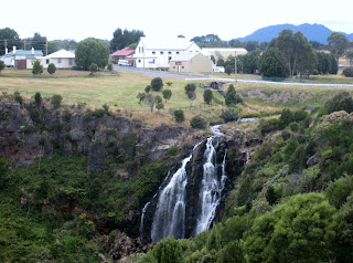
THURSDAY 9 - SATURDAY 11.2.2012: Stopped for lunch at Waratah (Population 227), and to view the waterfall.  Waratah was constructed to support a tin mine at Mount Bischoff. The town is built at the top of a waterfall, and water was diverted from the stream to provide water for mine sluicing and processing. Onward to Wynyard where we spent one night at the Wynyard Showground and then found yet another paradise - Oldina Picnic Area. The vista, camp fire and barbecue - enjoying the sound of the "babbling brook" and the "crackling fire" - perfect! We have planned a return visit.    
  
 
JUST LOVE THE GREAT OUTDOORS - NOT!

ROSEBERY - POPULATION: 1,032

WEDNESDAY 8.2.2012: Rosebery is a town situated at the northern end of the West Coast Range, in the shadow of Mount Black and adjacent to Lake Pieman. The Rosebery Mine has operated continuously since 1936, with 75 year celebrations held during February, 2011. The mine is currently operated by Minerals and Metals Group Ltd (MMG), producing zinc, lead, copper, silver and gold. We stayed at Stitt Park, Rosebery. The Lions Club have developed a nearby picnic area which we certainly appreciated - made for a lovely stay.

Monday, February 13, 2012

ZEEHAN - POPULATION: 845

TUESDAY 7.2.2012: Continuing on our west coast journey we pulled into Frank Long Memorial Freedom Camp at Zeehan. The region has one of the oldest histories of any part of Tasmania, when Abel Tasman sighted this part of the state in 1642. An early port for Zeehan was Trial Harbour but it was very precarious in its location on Ocean Beach and was overtaken by Strahan. We felt a little uneasy with the area so we readied the motorhome for a midnight evacuation if need be, and reassured ourselves that we had passed Zeehan Police Station, 5 minutes away in the main street. PLUS, we had phone reception! We made it through the night and headed off to the Zeehan West Coast Heritage Centre which incorporates the West Coast Pioneers Museum. It was excellent and far more information and exhibits than we had anticipated. Included was an underground mine simulation, Blacksmith shop, Mineral Exhibition, pictorial history of the West Coast, Machinery Shed, Train Yard, Power House, Miners' Hut and that is just to name a few! You could also visit the Gaiety Theatre Grand Hotel (built in 1898), and watch an Edwardian film, Court House and Masonic Lodge.
GAIETY THEATRE GRAND HOTEL (1898)
   
THEATRE'S PIPE ORGAN


CROCOITE -
TASMANIA'S
MINERAL EMBLEM


OH, forgot to mention the most important display, "Tribute to the Police Station". YEP, last night's safeguard became today's exhibit!